Ladakh in August 2009 – with my older son Andy. Unfortunately, Paul could not get time off work.
Sikkim in October 2010 – with Paul and John Beer
Bhutan in October 2013 – with Paul
All the trips were CTC holidays led by Pat and John Ashwell. Pat and John have the right level of hands-off group management to encompass the needs of fast and slower riders, and their tours are very well organised.
The tiny, isolated Himalayan kingdoms of Ladakh, Sikkim, and Bhutan are squeezed between the powerful countries of China and India. For centuries their monarchs enjoyed absolute power in their mountain strongholds, venerated by their subjects as embodiments of gods, but in the 20th century the supremacy of these domains fell. In 1947, partition left Ladakh a part of India, Sikkim became India’s twenty-second state in 1975, and in 2005 Bhutan became a constitutional monarchy.
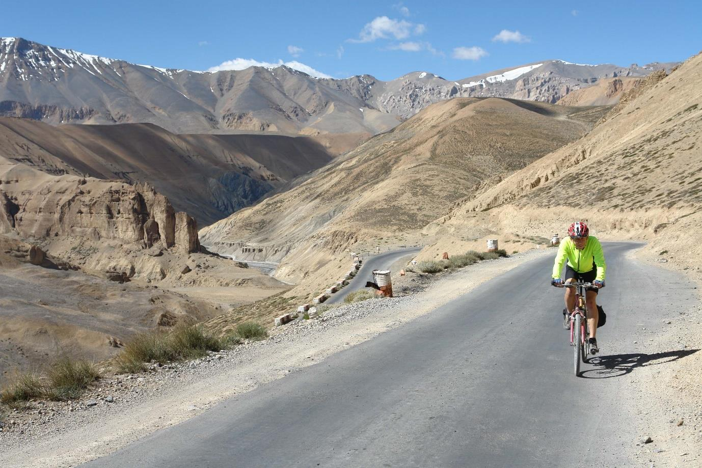
Ladakh, one of the highest regions in the world, frequently called Little Tibet, offers remote high-altitude beauty and dramatic scenery with elaborately decorated Buddhist sanctuaries, stupas, and former royal palaces set in the nearby rugged valleys amidst magnificent towering crags.
Ladakh was a very important trade route in Asia and collected taxes on goods that crossed their kingdom. However, this trade dried up when China closed the borders with Tibet and central Asia. The Indian government has encouraged tourism in Ladakh rather than in the troubled Kashmir region where territorial conflict, primarily between India and Pakistan, is still active.
The tour takes the classic Manali to Leh route passing through two 5000 m and two 4900 m high passes with spectacular scenery. The safe cycling window in the mountains is limited as the weather can be extreme. The 474 km long highway begins from Manali and is normally open from June 01 and officially closes on September 15 every year; in practice it remains motorable till the end of October (‘official’ means that the Indian government won’t airlift you if you get trapped in snow). Foreigners must obtain an Inner Line Permit (ILP) to visit Ladakh as well as an Indian Visa.
We went mid-August at the end of the monsoon period and the beginning of the winter season. Groups have been caught in extreme weather, so our back-up transport was adequate to transport us all in such a case.
The tiny, isolated Himalayan kingdoms of Ladakh, Sikkim, and Bhutan are squeezed between the powerful countries of China and India. For centuries their monarchs enjoyed absolute power in their mountain strongholds, venerated by their subjects as embodiments of gods, but in the 20th century the supremacy of these domains fell. In 1947, partition left Ladakh a part of India, Sikkim became India’s twenty-second state in 1975, and in 2005 Bhutan became a constitutional monarchy.
LADAKH TOUR
Ladakh, one of the highest regions in the world, frequently called Little Tibet, offers remote high-altitude beauty and dramatic scenery with elaborately decorated Buddhist sanctuaries, stupas, and former royal palaces set in the nearby rugged valleys amidst magnificent towering crags.
Ladakh was a very important trade route in Asia and collected taxes on goods that crossed their kingdom. However, this trade dried up when China closed the borders with Tibet and central Asia. The Indian government has encouraged tourism in Ladakh rather than in the troubled Kashmir region where territorial conflict, primarily between India and Pakistan, is still active.
The tour takes the classic Manali to Leh route passing through two 5000 m and two 4900 m high passes with spectacular scenery. The safe cycling window in the mountains is limited as the weather can be extreme. The 474 km long highway begins from Manali and is normally open from June 01 and officially closes on September 15 every year; in practice it remains motorable till the end of October (‘official’ means that the Indian government won’t airlift you if you get trapped in snow). Foreigners must obtain an Inner Line Permit (ILP) to visit Ladakh as well as an Indian Visa.
We went mid-August at the end of the monsoon period and the beginning of the winter season. Groups have been caught in extreme weather, so our back-up transport was adequate to transport us all in such a case.

The group flew to Delhi, stayed overnight and then flew to Manali which is at 2000 metres, so we stayed a day to acclimatise, and rode locally to visit our first temple at Nagar. Manali is situated in a green valley at the base of the Himalayas, so the climbing began as we headed into the mountains to camp at 3320 m. We had rain as we were still in the shadow of the monsoon and the route was still green with pine and deodar trees.
The next day took us out of the green monsoon zone, and we entered a barren landscape devoid of any significant vegetation. Ladakh is shadowed by the mighty Himalayas and the rain clouds of Indian monsoon reach the mountain barrier and stop, and never get to enter Ladakh to give rain. The moonscape scenery is spectacular.
Our route took us over the following passes:
Rhotang La pass – 3950 m,
Baralacha La pass – 4850 m,
Narmkeela La pass – 4950 m,
Lachlang pass – 5090,
Taglang La pass – 5332 m (similar elevation to Base Camp Everest)
Rhotang La pass – 3950 m,
Baralacha La pass – 4850 m,
Narmkeela La pass – 4950 m,
Lachlang pass – 5090,
Taglang La pass – 5332 m (similar elevation to Base Camp Everest)
The roads were sometimes surfaced at lower levels but at the higher elevations were dirt and gravel. Minor landslips were common, but we were lucky as we did not have to make any detours. Traffic was quite light, and you could always hear and see an approaching dust cloud. The main threat was Indian Army Convoys who patrolled the route and did not give way for anything.
The roads are under constant repair by the BRO. The Border Roads Organisation (BRO) is a road construction executive force in India that provides support to and is now a part of the Indian Armed Forces. BRO develops and maintains road networks in India's border areas and friendly neighbouring countries. BRO place warning signs at difficult areas and the puns are quite amusing.
I am curvaceous be slow
Overspeed is a knife that cuts a life
Let your insurance policy mature before you
The BRO workers sometimes camp by the roadside in very minimum facilities and our support crew would sometimes stop and give them some snacks and water.
We had 7 nights under canvas, and I don’t think there was any alternative accommodation as the route has few developed areas. The tents, mattresses and sleeping bags were four seasons quality so we were not cold at night. The support group were great, and each day went ahead and pitched the site before we arrived. They had tea and biscuits ready when we arrived and hot water for washing. In the morning they struck camp after we had left, and an advance party drove ahead to organise roadside snacks and lunch. Lunch was either a roadside picnic or sometimes in a bar.
The campsites were usually in a valley, so we had spectacular views of sunsets and sunrises over the mountains. Once the sun set the temperature plummeted, but we had a large mess tent and a gas heater for communal meals. The group was an interesting mix of people, as with all CTC tours I have been on, so meal-time conversation was good fun.
The food was good consisting of what could be sourced locally – rice, dal, flapjacks, eggs, porridge and tea. The support group always made sure that we had a supply of Tiger beer.
The campsites were chosen as far as possible to be lower than the highest elevation reached during the day as this reduces the impact of altitude sickness. I personally found the sleeping difficult as I kept waking up because of my breathing and I developed a cold, so I welcomed the descent to Rumpste and 3 nights in a hotel in Leh at only 3400 m. I did not have any significant problems on the Nepal and Tibet trip which backs up comments that altitude problems are not predictable and not related to fitness.
Our final challenge was Khardung La pass at 5359 m, which has been frequently referred to as the highest motorable pass at 5,359 m (17,582 ft). However there have been reports which claim that a well-graded Indian military road at 5,610 metres (Mana Pass on the India-Tibet border) is higher.
The climb from Leh to the top of the Khardung La pass is 41 kms long and has an elevation gain of 2200 m. The last 10 kms are unsurfaced and the bends seemed to be very steep, but at this height power output is very low. Because of the reduced barometric pressure, the effective oxygen concentration is approximately 50% of that at sea level – 20.9 % at sea level compared to 10.7 % at 5350 m.
The view from the top of the Khardung La is spectacular stretching from the Indus valley in the South over the endless peaks and ridges of the Saser Massif in the North.The climb took about 4 hours, but it did not take long to return to Leh. All the ladies in our group completed the climb but several men opted out.
Leh is a bustling town and frequented by young travellers so quite different from the high mountains. There are narrow streets to explore and plenty of small shops, eating places, and Leh palace and Sakar Gompa monastery to visit.
We returned via Delhi and booked a tour of Delhi with a difference – Cycle Old Delhi. We were issued with old style bikes, and we visited many narrow streets and markets and saw Delhi as few people have seen. Safe working practices do not exist – we saw men using pickaxes and jack hammers wearing flip flops. The organiser was trying to establish the Cycle Old Delhi tour and I hope he was successful as it was great fun.
We had a day to explore so Andy and I used the metro. It was very crowded, and we were both relieved of our small pocket cameras. In my case I had my camera in a zipped pouch in front of me but that was ineffective as I felt somebody thump me in the stomach and my camera was gone. The morale is to avoid crowds. The hotel arranged a rapid response – for us to visit the local police station by rickshaw. The police would not issue a stolen items report as we could not prove that we had been pickpocketed, but after a lengthy discussion they agreed to issue a lost report which was good enough for the insurance claim. I think the incident which would make a good basis for a comedy clip. Unfortunately, our photos were on the memory cards which was the real loss – we were kindly given photos by group members.
There is much written about the caravans that crossed the silk road – Leh was a major crossroads. The Silk Road that began in the second century, thrived for 1,600 years until the Ottoman Empire closed trade with China in the 14th Century.
It was an arduous passage as the Ladakhi traders had to cross over the Khardung La at 5,359 metres. They journeyed from the head of the Nubra valley through the Sasser La at 5,411 metres across the Depsang Plains at 5,376 metres to reach the cold desert of Daulat Beg Oldie (DBO) at the easternmost point of the Karakoram range and finally over the Karakoram Pass at 5,540 metres before they could reach Yarkhand.
Despite the harsh climate and the inhospitable terrain of the Himalayas, apart from the fear of being looted by bandits and dacoits, every year, hundreds of caravans embarked on this long journey that took several months. This Pass is still strewn with bones and skeletons of pack animals that died due to lack of vegetation. It is popularly known as the Skeleton Trail.
Other references record that if you could not keep up you were abandoned by the roadside to freeze. CTC tours would not allow this practise, so we had the alternative of the minibus.
In summary the Ladakh trip was an experience but a challenge. Don’t try it if you moan about the North Downs.


SIKKIM
We travelled to Bagdogra in West Bengal via Delhi. Foreigners must obtain an Inner Line Permit (ILP) to visit Sikkim as well as an Indian Visa. The route was circular entering Sikkim from Darjeeling and travelling to Mangan as the furthest point North.
Our route did not enter the high mountains and the highest elevation reached was 2100 metres. The roads were surfaced but with rough and broken stretches and many of the hills were very steep; some of the descents were challenging. We were given the option of vehicle transport on one long wet downhill section with poor road surfaces – I found it was OK with good V brakes and nerves – just!

We were also recommended to take the vehicle on one climb which the support team said was just too steep to ride and at least 10 kms long. I thought the description of the elevation gain defied the geography, so I rode. It was like riding half a dozen consecutive Whitedown Hills but the reward at the top was more spectacular views and a lovely ride along a ridge.
Sikkim is very beautiful and most days we rode in the foothills and had views of the snow-capped mountains. Tea plantations rolled across the countryside with purple Jacaranda trees making a vivid contrast.
The villages are picturesque with livestock wandering around. It is difficult to see what employment there is apart from rudimentary farming. The Indian government is trying to give people a job, but the only evidence of this was ladies dressed in their colourful saris breaking rocks using hand tools, sitting at the roadside under large umbrellas as protection from the sun.
Some of the hotels were old colonial buildings and you could experience the colonial lifestyle – lovely gardens – stunning views – 4 poster beds – thick carpets – heavy wooden furniture and cushions – lots of tea and biscuits – elegant dining rooms – ceiling fans slowly rotating – typical Indian food and wonderful service. Don’t forget the Tiger beer.
In contrast we stayed one night in the Mount Norsing Village Resort which is a collection of huts with unforgettable 360-degree views of the white mountain peaks. We were transported to the resort by jeeps as the approach track was unrideable.
In Darjeeling we visited the Sherpa Tenzing museum which has a good collection of old and new equipment used by Tenzing Sherpa and others. It really shows how primitive the early equipment was. The museum also displays the history of mountaineering around the Himalayas.
We did not find a chance to travel on the Darjeeling Himalayan Railway, also known as the DHR or the Toy Train. It is a 610 mm (2 ft) gauge railway that runs between New Jalpaiguri and Darjeeling. Must be worth a train trip for any enthusiasts.
We visited several temples and each one was impressive both in architecture and the dedication of the priests. Rather than risk temple fatigue I won’t go into detail.


BHUTAN
Bhutan imposes a minimum visa fee per night so a trip to Bhutan is quite expensive, but the scenery is spectacular, and Bhutan must still get enough tourists to justify the pricing policy.
We travelled via Delhi to Paro. The flight from Delhi to Paro is subject to good weather and we just made it before heavy rain and high winds closed the airport. We arrived in Delhi during a festival which was probably Divali, wandering in the back streets was good fun as people were dressed in their finery, candles were burning in shops and houses and groups were parading large papier-mache statues. In one area they had constructed a temporary shrine and people were filing past an amazing display of candles and decorations. In the evening there was a musical event.
Our cycling route took us east from Paro to Sarndrup JongKhar – see map below. Road surfaces were generally good and gradients manageable. Accommodation was 11 nights in comfortable hotels or guest houses, and 4 nights camping in the more remote regions. One of the campsites was in the grounds of a temple – a lovely location with a bonus early morning call of chanting. The highest elevation of the trip 3225 m was the campsite at Ura. I vividly recall the warmth from a big bonfire and the incredible star scape.
There was a lot of climbing but as we were mainly below 3000 m altitude effects were limited.
Our first day was a trek to Paro Taktsang, also known as the Tiger’s nest. This is a sacred Vajrayana Himalayan Buddhist site located in the cliffside of the upper Paro valley in Bhutan. It is said to be oneof thirteen Tiger's Nest caves in historical Tibet in which Padmasambhava practiced and taught Vajrayana. It is believed that Padmasambhava flew to this location from Singye Dzong on the back of a tigress. This place was consecrated to tame the Tiger demon.
The Tiger’s Nest is built into the rock face and the logistics of the construction must have been an incredible challenge as access is very limited. We visited several temples on the tour and each one was impressive, but the Tiger’s Nest is high on my list of must visit sites.
From Sarndrup JongKhar we had a 3-hour road transfer to Guwahati airport. Security was tight and we were stopped at several check points. A few of us needed to stop for the call of nature which is the only time I’ve had a pee whilst being protected by a guard with a gun.
The scenery in Bhutan is spectacular, food was good, the company was fun, so cycling was a pleasure.
Here is the link to the Bhutan video. https://www.youtube.com/watch?v=JSV6CbM8luI


Summary
The Nepal and Tibet trip was probably the most spectacular and enjoyable because of Everest combined with overnights in several interesting towns, but the remoteness of the Ladakh landscape is also special. Both trips were physically tough. Perhaps the opening-up of Tibet, with road improvements and access by rail now increasing tourism, would make me think twice of re-visiting Everest.
Sikkim and Bhutan were very pretty and easier riding, but from the perspective of a bike saddle viewpoint I think Sikkim edges out Bhutan. Perhaps the paddy fields and limestone karsts of Vietnam are a comparable cycling experience but that’s another tour.
~ Ken & Paul Day
This report was first published in The Sou'Wester, May-June 2023 edition.
No comments:
Post a Comment
Thanks for your comment. Comments are occasionally sent to the admins for approval, so your comment may not appear immediately.